As of today, peak season now, through ~December 31. Earth Exhibit tracks the live conditions and flags it the moment it is on.
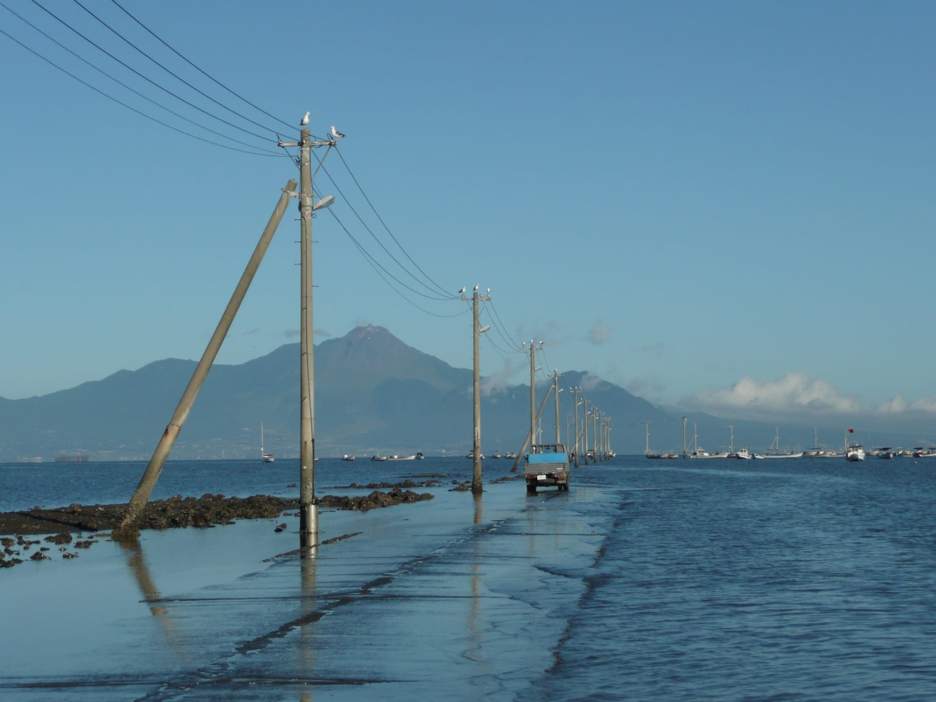
The utility poles stand in a perfect line across open water. No road, no land, just wooden posts marching toward the horizon. Then the tide turns. Over the next six hours, the Ariake Sea pulls back more than four meters, exposing a ribbon of asphalt and mud that fishermen drive across to reach their seaweed farms. Built in 1979 for fishermen operating in the Ariake Sea, the road stretches 1.2 kilometers into what becomes, twice daily, the largest tidal flats in Japan.
The Science Behind Nagabeta Kaishoro
The Ariake Sea's deepest point reaches only 20 meters, and extreme tides exceed four meters , creating the most dramatic tidal range in Japan. This shallow basin, surrounded by Kyushu's four northern prefectures, acts like an enormous tidal amplifier. The tidal flats are replenished with volcanic ash carried from Mount Aso and Mount Kuj? by the Chikugo River , building the muddy substrate that supports nori (seaweed) cultivation.
The counterclockwise flow of sea currents, combined with the six-meter variation between high and low tides, has led to the formation of large tidal flats . When the water recedes, it leaves behind shallow pools across the mud. The road surface, submerged for half the day, reflects the sky during calm conditions at low tide, creating the mirror effect that has made Nagabeta Kaishoro a social media phenomenon.
The timing matters. The best viewing window occurs two hours before and after the lowest tide , when shallow water remains on the flats but the road itself is exposed. Too early and the road is still underwater. Too late and the mud loses its reflective sheen.
When and Where to See the Tidal Road
Nagabeta Kaishoro is located in Uki City on the Ariake Sea coast, west of central Kumamoto. The road is within Sumiyoshi Seaside Park , where parking is available near the viewing area.
The phenomenon occurs year-round, governed entirely by the lunar tidal cycle rather than seasonal changes. Check tide tables for Kumamoto's Ariake Sea coast before planning your visit. The lowest tides of each month, occurring during new and full moons, provide the most dramatic exposures. Low tide coinciding with sunset happens only a few days per year, making that overlap particularly valuable for photography .
Dusk offers the strongest conditions. The low angle of light intensifies reflections, and the setting sun behind Mount Unzen (visible across the Ariake Sea on clear days) adds color to both sky and water. Dawn works too, but fewer fishermen are active and the eastern light lacks the warmth of evening.
Access requires a car. From Kumamoto Airport, drive 40 to 60 minutes west toward the coast. From Kumamoto Station, allow 45 to 75 minutes. Public transit is impractical for timing your visit with specific tide windows. Visitors relying on trains face about three kilometers of walking and long waits between services .
Your Witnessing Guide
Arrive 90 minutes before low tide. The road will still be submerged, but you'll watch the transformation as water drains away and reflections develop. Wear waterproof hiking boots with good tread. The road surface becomes very slippery the farther out you walk , especially where algae clings to the asphalt.
For photography, bring a zoom lens to compress the line of utility poles and emphasize their march into the distance. A polarizing filter can control reflections, though you may want them at full strength. ISO 400, aperture f/8 to f/11 for depth of field, and shutter speeds around 1/250 second work in good light. Use a tripod if you're shooting near dusk and want slower speeds to smooth water or capture long exposures of the sky.
Do not walk onto the road during rising tide. The Ariake Sea experiences extreme tides that can exceed four meters , and incoming water moves faster than you expect across flat terrain. Watch for fishing trucks. Fishermen drive onto the road to load seafood before the tide returns , and they have the right of way. Never block the road or stand in vehicle paths.
Binoculars help spot wading birds on the flats. Bring water, sun protection, and insect repellent. The mud generates warmth and moisture that mosquitoes love during warmer months. A shop beside the parking area has a toilet and sells snacks .
A statue of Jinbe, a character from the manga One Piece, stands in Sumiyoshi Seaside Park as part of the One Piece Kumamoto Reconstruction Project following the 2016 earthquake . The statue faces the tidal road with a raised sake cup, a surreal addition to the already otherworldly scene.
Why It Matters
The Ariake Sea represents 40 percent of Japan's total tidal flat area , making it critical habitat for species adapted to extreme tidal environments. Mudskippers, pen shells (Atrina pectinata), and fiddler crabs live in the Ariake Sea's tidal zones . The Arao Tidal Flats just north of Nagabeta were designated a Ramsar Wetland in 2012, recognizing their importance as stopover and wintering sites for migratory shorebirds along the East Asia-Australasian Flyway.
The road is used to cultivate nori seaweed , a cornerstone of Japan's culinary economy. The tidal flats support aquaculture that depends on the twice-daily exposure and submersion cycle. Fishermen time their work to the tide with precision honed over generations, loading trucks with harvested shellfish and seaweed in the narrow window between tides.
The road itself has become a conservation ambassador of sorts. Its viral spread on social media has drawn attention to the Ariake Sea's unique ecology and the human communities that depend on it. Visitors arrive expecting a Spirited Away aesthetic and leave having witnessed a working landscape where people and tides move in coordinated rhythm.
This is the short version
This page shows a taste. The app has the full list of where to see this, the exact timing, and live conditions for 1,000+ natural phenomena worldwide, so you know the moment one is genuinely worth the trip.