As of today, out of season, returns ~January. Earth Exhibit tracks the live conditions and flags it the moment it is on.
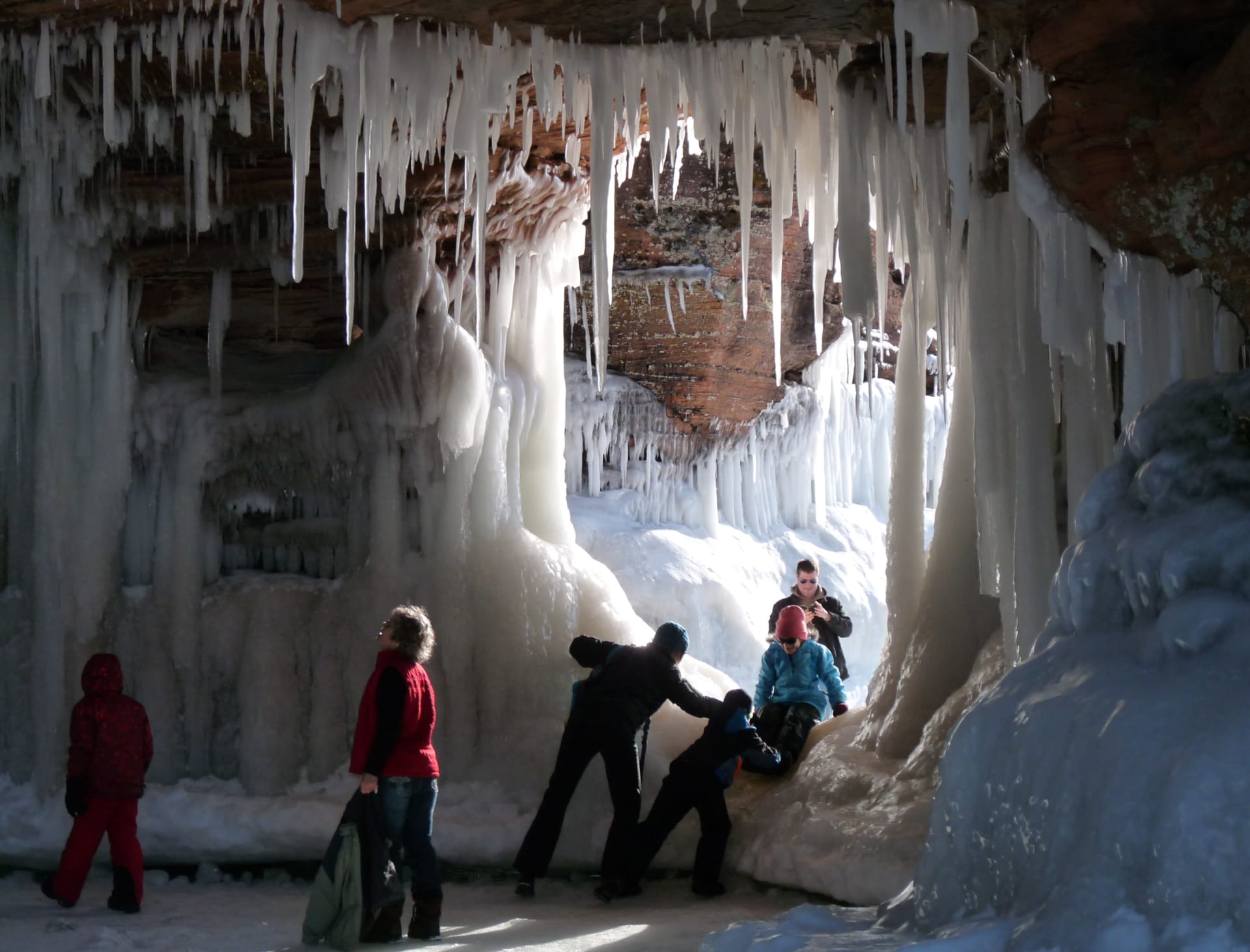
The first thing you hear is dripping. Not the steady patter of a leaky faucet, but an irregular, percussive rhythm echoing off sandstone walls that haven't seen open air in months. You step off the frozen lake surface and into a chamber where icicles hang in columns as thick as telephone poles, their surfaces rippled with frozen wave patterns. The light filtering through the ice overhead is a deep, saturated blue, the kind of color you associate with glaciers or the very bottom of a swimming pool. Your breath condenses instantly. The temperature inside these formations hovers around minus 9 degrees Celsius, but the wind that was cutting across the open ice behind you is gone. It is perfectly still. And then you look up and see it: a frozen cascade pouring from a cleft in billion-year-old red sandstone, suspended mid-flow, every droplet locked in place.
This is what happens when the largest freshwater lake on Earth decides to freeze.
The Science Behind the Ice Architecture
The Apostle Islands ice caves are not caves in the traditional geological sense. They are hybrid formations, part ancient sandstone sea cave, part seasonal ice sculpture, rebuilt from scratch each winter by a collaboration between rock, water, and cold.
The underlying structure belongs to the Oronto Group sandstone, roughly 1 billion years old. These red-brown cliffs along the Bayfield Peninsula and the archipelago's 21 islands were shaped over millennia by Lake Superior's relentless wave action. The sandstone is relatively soft, and the waves have carved alcoves, arches, overhangs, and true sea caves into the shoreline. In warmer months, you can kayak past them. But in winter, they transform.
The process begins when air temperatures drop and stay below freezing for extended periods. Lake Superior, which holds 10% of the world's surface freshwater, resists freezing. Its sheer thermal mass means the lake can absorb enormous amounts of cold before ice begins to form. But when sustained Arctic air settles over the western basin, shore ice starts to build. Waves continue to crash against the cliffs even as ice thickens along the waterline. Each splash freezes on contact, adding another translucent layer to the growing formations. Icicles descend from cave ceilings. Frozen curtains seal off alcove entrances. Flowstone-like ice sheets coat interior walls.
The result is a landscape that looks almost biological, as if the caves are growing crystalline organs. The blue-white coloration comes from the same physics that make glaciers blue: when ice is compressed or formed in layers, it absorbs red wavelengths of light and transmits blue. The deeper you look into the formations, the more intense the blue becomes. Against the iron-rich red of the billion-year-old sandstone, the contrast is staggering.
But here is the critical variable: the lake itself must freeze solid enough to walk on. The caves sit at the base of cliffs that rise directly from the water. There is no land approach to the most spectacular formations at Meyers Beach. The only way in is across the frozen lake surface. The National Park Service requires a minimum of 10 to 12 inches of solid ice before they will open access. Rangers drill test holes, measure thickness, and evaluate structural integrity before making the call.
Some winters, the caves never open at all. The phenomenon is entirely dependent on prolonged, severe cold. In the winter of 2013-2014, the caves opened for the first time in five years, and an estimated 138,000 people visited. Other years, a January thaw or insufficient freeze-up keeps them locked away. This unpredictability is fundamental to what makes the ice caves what they are. They cannot be scheduled, cannot be guaranteed, and cannot be manufactured.
When and Where to Go
The ice cave season, when it happens, runs from roughly January 20 through March 20, with February as the core month. This is when ice thickness is most likely to reach safe levels and when the formations are at their most elaborate.
Three primary locations host the most significant formations:
Meyers Beach Ice Caves (46.88N, 91.05W) sit along the mainland shore approximately 18 miles east of Bayfield, Wisconsin. This is the most accessible site and the one the National Park Service monitors most closely. When the caves are open, you walk approximately one mile across the frozen lake surface from the Meyers Beach trailhead to reach the cliff formations. The caves here are extensive, with multiple chambers, frozen waterfalls, and ceiling formations that catch midday light.
Stockton Island shoreline (46.93N, 90.59W) offers a wilder, less-visited experience. Stockton is the largest island in the archipelago, and its northern shore features sandstone cliffs with deep wave-cut alcoves. Reaching them in winter requires a longer ice crossing and more logistical planning. Few visitors make the trek, which means the ice formations remain untouched and the silence is absolute.
Devils Island and Raspberry Bay (47.07N, 90.73W) represent the northernmost extent of the Bayfield Group. Devils Island has some of the most dramatic sea caves in the archipelago, with narrow slot passages and chambers that amplify sound. In winter, ice fills these passages in extraordinary formations. Access is the most challenging of the three sites and is rarely feasible for casual visitors.
Before planning any visit, check the National Park Service ice line (715-779-3397) and the Apostle Islands National Lakeshore website. Conditions change rapidly. Ice that was 14 inches thick on Monday can develop pressure cracks by Wednesday. The NPS will close access without warning if conditions deteriorate.
Photographing and Witnessing the Formations
The ice caves reward patience and preparation in equal measure.
Arrive at midday. This runs counter to the golden-hour instinct most photographers carry, but the caves face north and northeast along the Meyers Beach stretch. Midday sun is the only light that penetrates deep into the chambers, illuminating the ice from behind and producing that luminous blue glow. Morning and late afternoon leave the interiors in flat shadow.
For gear, bring a wide-angle lens in the 14-24mm range. The cave interiors are tight, and you will want to capture ceiling-to-floor formations from close range. A tripod is essential for the low-light interiors, where exposures of 1 to 10 seconds at f/5.6 to f/11 and ISO 100 to 800 are typical. A polarizing filter cuts surface glare on the ice and deepens the blue tones. Bracket your exposures aggressively. The dynamic range between a bright cave entrance and a deep interior shadow can exceed 8 stops.
Condensation is your enemy. Moving from the subzero exterior into a slightly warmer cave chamber (or worse, back into a heated car) will fog every lens surface instantly. Keep your camera in your pack until you reach the caves. Let it acclimate for five minutes before shooting. When you leave, seal it in a ziplock bag before entering any warm space and let it equalize slowly.
Beyond the camera, practical gear matters more here than at most phenomena sites. Wear sturdy boots with aggressive tread. The ice surface is uneven, with pressure ridges, refrozen melt pools, and slick patches. Hiking poles or traction cleats (Yaktrax or microspikes) dramatically reduce your chances of a fall. Bring a headlamp or flashlight for exploring deeper chambers. Pack water, high-calorie snacks, and a basic first-aid kit. Cell service is unreliable along the Bayfield Peninsula, and you are walking on a frozen lake a mile from shore. Treat it with the seriousness it deserves.
The experience itself is difficult to overstate. You are standing inside a living geological process. The ice shifts and groans. Occasionally, a deep, resonant boom rolls across the lake surface as a pressure crack propagates, a sound that travels through your feet before it reaches your ears. Water drips from active formations. The sandstone walls, stained with iron oxide and shaped by ten thousand years of waves, are suddenly inches from your face, close enough to see individual grain boundaries in the rock. It is geology at two timescales simultaneously: the billion-year patience of sandstone and the six-week frenzy of ice.
The Bigger Picture
The Apostle Islands ice caves exist at a threshold. They require a specific combination of sustained cold, adequate snowpack to insulate shore ice, calm enough conditions to prevent breakup, and enough wave energy before the freeze to build the initial ice layers. Remove any one variable and the phenomenon fails to materialize.
Lake Superior's winter ice coverage has declined by roughly 80% since 1973, according to NOAA Great Lakes Environmental Research Laboratory data. The trend is not linear (the brutal winter of 2013-2014 produced near-total ice coverage), but the direction is unmistakable. Winters warm enough to keep the caves closed are becoming more frequent. The five-year closure before the 2014 opening was unprecedented in park records. Longer closures are statistically likely in the decades ahead.
This makes each opening feel urgent in a way that has nothing to do with tourism marketing. The ice caves are a real-time indicator of continental climate patterns. When they open, it means the upper Midwest has experienced a genuine, sustained deep freeze, the kind that kills invasive species, recharges aquifers, and resets ecological clocks. When they stay closed, it means something has shifted.
For now, the caves still form. The billion-year-old sandstone still stands. Lake Superior still freezes, some years, enough to walk on. And when it does, those chambers fill with blue light and the sound of dripping water and the low groans of a frozen inland sea, and for a few weeks, one of North America's most extraordinary geological intersections is open for business.
This is the short version
This page shows a taste. The app has the full list of where to see this, the exact timing, and live conditions for 1,000+ natural phenomena worldwide, so you know the moment one is genuinely worth the trip.